
Viša rezolucija nije dostupna.
Trnc-map.gif ((508 × 300 piksela, veličina datoteke: 10 KB, <a href="/wiki/MIME" title="MIME">MIME</a> tip: image/gif))
| Ova je datoteka sa stranica Zajedničkog poslužitelja Zaklade Wikimedije i smiju je rabiti drugi projekti. Opis s njezine stranice s opisom datoteke prikazan je ispod. |

|
This map has been uploaded by Electionworld from en.wikipedia.org to enable the |

|
The copyright holder of this work allows anyone to use it for any purpose including unrestricted redistribution, commercial use, and modification.
Usage notes:
|
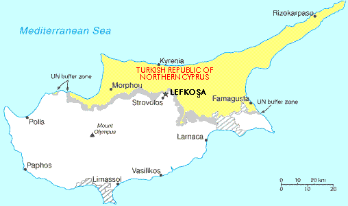
Map showing the Turkish Republic of Northern Cyprus (in yellow). The tiny exclave is called Erenköy.
Povijest datoteke
Kliknite na datum/vrijeme kako biste vidjeli datoteku kakva je tada bila.
| Datum/Vrijeme | Minijatura | Dimenzije | Suradnik | Komentar | |
|---|---|---|---|---|---|
| sadašnja | 22:56, 28. studeni 2006. | | 508 × 300 (10 KB) | wikimediacommons>Electionworld | {{ew|en|Expatkiwi}} {{CopyrightedFreeUse}} Map showing the Turkish Republic of Northern Cyprus (in yellow). The tiny exclave is called Erenköy. Category:Maps of Northern Cyprus |
Poveznice
Na ovu sliku vode poveznice sa sljedećih stranica: