
Polutok_Klek_i_granica.JPG ((434 × 300 piksela, veličina datoteke: 32 KB, <a href="/wiki/MIME" title="MIME">MIME</a> tip: image/jpeg))
| Opis |
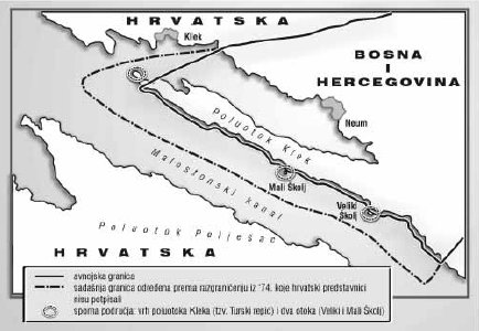
Hrvatski: Poluotok Klek i granica R. Hrvatske i BiH English: Klek peninsula and boarder between Republic of Croatia and Bosnia and Herzegovina |
||
| Datum | |||
| Izvor | http://upload.wikimedia.org/wikipedia/bs/3/3f/Bosansko_poluostrvo_Klek.jpg | ||
| Autor | archy | ||
| Dopuštenje (Naknadna uporaba ove datoteke) |
|

|
This map image could be re-created using vector graphics as an SVG file. This has several advantages; see Commons:Media for cleanup for more information. If an SVG form of this image is available, please upload it and afterwards replace this template with
{{vector version available|new image name}}.It is recommended to name the SVG file “Polutok Klek i granica.svg”—then the template Vector version available (or Vva) does not need the new image name parameter. |


Povijest datoteke
Kliknite na datum/vrijeme kako biste vidjeli datoteku kakva je tada bila.
| Datum/Vrijeme | Minijatura | Dimenzije | Suradnik | Komentar | |
|---|---|---|---|---|---|
| sadašnja | 08:02, 17. listopad 2012. | Nema minijature | 434 × 300 (32 KB) | commons>Quahadi | {{Information |Description=Poluotok Klek i granica R. Hrvatske i BiH Klek peninsula and boarder between Republic of Croatia and Bosnia and Herzegovina |Source=http://upload.wikimedia.org/wikipedia/bs/3/3f/Bosansko_poluostrvo_Klek.jpg |Date= 2008-07-11... |
Poveznice
Na ovu sliku vode poveznice sa sljedećih stranica: