

Veličina ovog PNG prikaza ove SVG datoteke: 450 × 456 piksela. Ostale razlučivosti: 237 × 240 piksela | 474 × 480 piksela | 758 × 768 piksela | 1.011 × 1.024 piksela | 2.021 × 2.048 piksela.
Vidi sliku u punoj veličini (SVG datoteka, nominalno 450 × 456 piksela, veličina datoteke: 419 KB)
| Ova je datoteka sa stranica Zajedničkog poslužitelja Zaklade Wikimedije i smiju je rabiti drugi projekti. Opis s njezine stranice s opisom datoteke prikazan je ispod. |
Sažetak
| Opis |
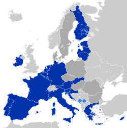
Deutsch: Eurozone
Staaten, die den Euro de jure angenommen haben Staaten und Gebiete, die den Euro de facto angenommen haben EU-Mitglieder außerhalb der Eurozone English: Eurozone
Countries using the Euro de jure Countries and territories using the Euro de facto EU member states that are outside the Eurozone Français : Zone euro
Pays ayant adopté l'euro de jure Pays et territoires utilisant l'euro de facto États membres de l'Union européenne n'ayant pas adopté l'euro Hrvatski: Eurozona
Članice Eurozone Države koje koriste Euro kao sredstvo plaćanja, ali su izvan Eurozone i Europske unije (Kosovo i Crna Gora) Članice Europske unije koje su izvan Eurozone Latviešu: Eirozona
Valstis, kuras izmanto eiro de jure Valstis un teritorijas, kuras izmanto eiro de facto Eiropas savienības dalībvalstis ārpus eirozonas Polski: Strefa Euro
Kraje używające Euro de jure Kraje i terytoria używające Euro de facto Członkowie Unii Europejskiej będący poza strefą Euro Português: Zona Euro
Países que adotaram de jure o euro Países e territórios que utilizam de facto o euro Estados-membros da União Europeia que não adotaram o euro Српски / srpski: Еврозона
Чланице еврозоне Државе и области, које користе Евро као средство плаћања, али су ван Еврозоне и Европске уније (Црна Гора и Косово) Чланице Европске уније, које су ван Еврозоне Українська: Єврозона
Країни, що використовують Євро де-юре Країни та території, що використовують Євро де-факто Країни-члени ЄС за межами єврозони فارسی: منطقه یورو
کشورهایی که یورو را به طور رسمی پذیرفتهاند کشورها و مناطقی که از یورو به عنوان وسیله پرداخت استفاده می کنند اما عضو منطقه یورو نیستند کشورهای عضو اتحادیه اروپا که خارج از منطقه یورو هستند |
| Datum | |
| Izvor | Europe countries.svg |
| Autor | Glentamara |
| SVG genesis |
Licencija
| Ja, nositelj autorskog prava za ovo djelo, prepuštam ovo djelo u javno vlasništvo. Ovo prepuštanje vrijedi za cijeli svijet. U nekim državama to nije pravno moguće; ako je tako: Dajem svima prava da koriste ovo djelo za bilo koju svrhu, bez ikakvih uvjeta, osim ako takvi uvjeti nisu propisani zakonom. |
Povijest datoteke
Kliknite na datum/vrijeme kako biste vidjeli datoteku kakva je tada bila.
| Datum/Vrijeme | Minijatura | Dimenzije | Suradnik | Komentar | |
|---|---|---|---|---|---|
| sadašnja | 18:51, 6. kolovoz 2024. | | 450 × 456 (419 KB) | wikimediacommons>Xolani | changed colors for accessibility and standardization reasons (see my page for more info). circled microstates for accessibility reasons. |
Poveznice
Na ovu sliku vode poveznice sa sljedećih stranica: