

Vidi sliku u punoj veličini (SVG datoteka, nominalno 2.921 × 1.500 piksela, veličina datoteke: 1,72 MB)
| Ova je datoteka sa stranica Zajedničkog poslužitelja Zaklade Wikimedije i smiju je rabiti drugi projekti. Opis s njezine stranice s opisom datoteke prikazan je ispod. |
| This file may be updated to reflect new information. If you wish to use a specific version of the file without it being overwritten, please upload the required version as a separate file. |
Sažetak
| Opis |
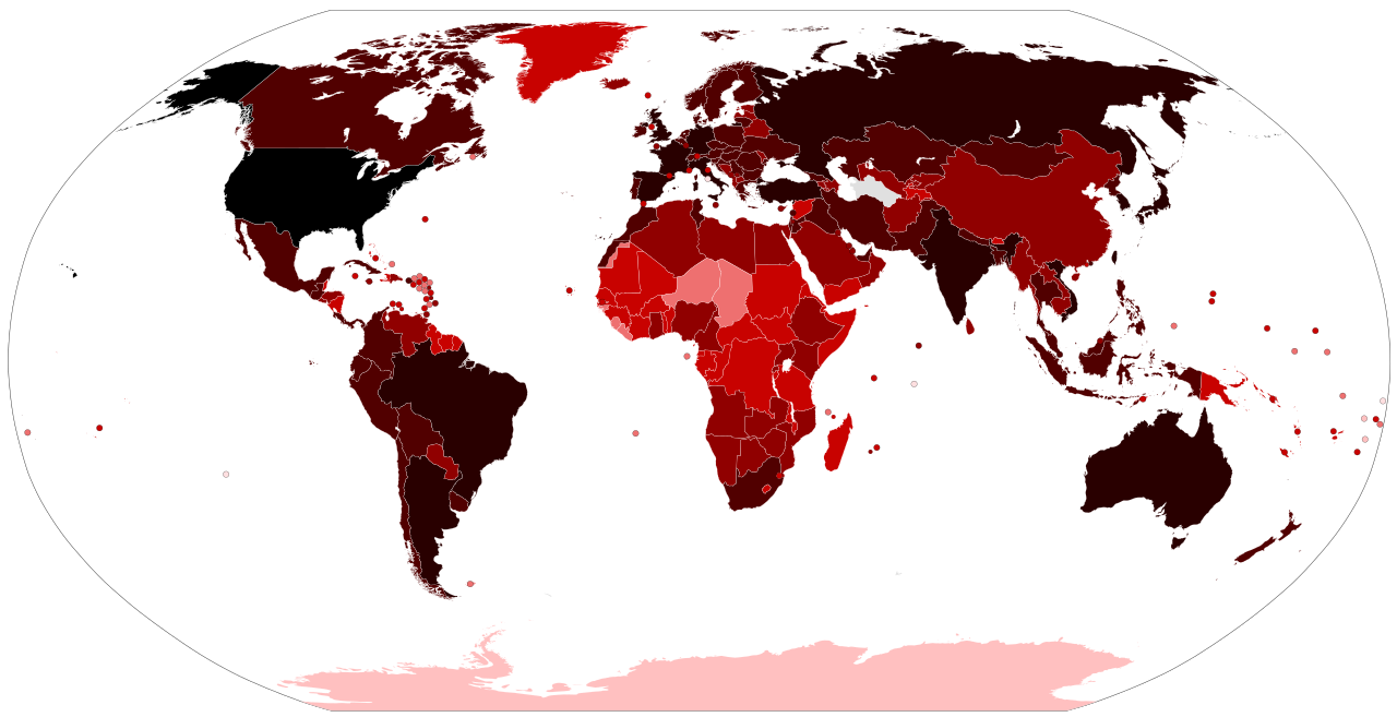
Map of the COVID-19 outbreak. Total cumulative confirmed COVID-19 cases by country. See the file history farther down for the latest upload date. Be aware that since this is a rapidly evolving situation, new cases may not be immediately represented visually. Refer to the primary article COVID-19 pandemic or the World Health Organization's situation reports for most recent reported case information. Legend information: 100,000,000+ Confirmed cases 10,000,000–99,999,999 Confirmed cases 1,000,000–9,999,999 Confirmed cases 100,000–999,999 Confirmed cases 10,000–99,999 Confirmed cases 1,000–9,999 Confirmed cases 100–999 Confirmed cases 1–99 Confirmed cases No confirmed cases, no population, or no data available |
| Datum |
– Date of first upload to the Wikimedia Commons. See the file history farther down for the latest upload date. Update the "point in time" date in the Wikidata entry linked below. {{wikidata|property|Q101240885|P585}} is used in map captions on Wikipedia. It provides the map date. To enable the date change click the purge link after updating the Wikidata entry. |
| Izvor |
Latest versions: https://ourworldindata.org/explorers/coronavirus-data-explorer?tab=map&Metric=Confirmed+cases&Interval=Cumulative&Relative+to+Population=false&Align+outbreaks=false&country=~OWID_WRL - Our World in Data. Click on the download tab to download map. The table tab has a table of the exact data by country. Source tab says data is from the COVID-19 Data Repository by the Center for Systems Science and Engineering (CSSE) at Johns Hopkins University. The map at the source is interactive and provides much more detail. For example, run your cursor over the color bar legend to see the countries that apply to that point in the legend. |
| Autor |
Various Commons editors. See file history for latest ones. Older versions: Svenskbygderna (original author); Ratherous, AKS471883 (contributors); authors of File:BlankMap-World.svg (source file) |
| Ostale inačice |
|
| SVG genesis |


Licencija
- Slobodno smijete:
- dijeliti – umnožavati, distribuirati i javnosti priopćavati djelo
- remiksirati – prerađivati djelo
- Pod sljedećim uvjetima:
- imenovanje autora – Morate pripisati odgovarajuće autorske zasluge, dati poveznicu na licenciju, te naznačiti jesu li načinjene promjene autorskog djela. Prethodno navedeno možete učiniti na svaki razuman način, ali ne na način koji bi sugerirao da Vi ili Vaše korištenje licencorova djela ima izravno licencorovo odobrenje.
Povijest datoteke
Kliknite na datum/vrijeme kako biste vidjeli datoteku kakva je tada bila.
| Datum/Vrijeme | Minijatura | Dimenzije | Suradnik | Komentar | |
|---|---|---|---|---|---|
| sadašnja | 14:21, 14. lipanj 2023. | | 2.921 × 1.500 (1,72 MB) | wikimediacommons>AKS471883 | Macao 10000 |
Poveznice
Na ovu sliku vode poveznice sa sljedećih stranica: