
Vidi sliku u punoj veličini ((1.545 × 1.242 piksela, veličina datoteke: 187 KB, <a href="/wiki/MIME" title="MIME">MIME</a> tip: image/gif), animacija se ponavlja, 14 okvira, 44 s)
Napomena: Zbog tehničkih ograničenja minijature GIF slika visoke rezolucije poput ove neće biti animirane.
| Ova je datoteka sa stranica Zajedničkog poslužitelja Zaklade Wikimedije i smiju je rabiti drugi projekti. Opis s njezine stranice s opisom datoteke prikazan je ispod. |

|
This image could be re-created using vector graphics as an SVG file. This has several advantages; see Commons:Media for cleanup for more information. If an SVG form of this image is available, please upload it and afterwards replace this template with
{{vector version available|new image name}}.
It is recommended to name the SVG file "Breakup of Yugoslavia.svg" - then the template Vector version available (or Vva) does not need the new image name parameter. |
Sažetak
Key:
| Yugoslavia (1943–1992) | |||
| Croatia (1991–present) | |||
| Herzeg-Bosnia (1992–1994) | |||
| UNTAES (1996–1998) | |||
| Federal Republic of Yugoslavia / Serbia and Montenegro (1992–2006) | |||
| Republika Srpska (1992–present) | |||
| Serbian Krajina (1991–1995/96) | |||
| Republic of Bosnia and Herzegovina (1992–1995) | |||
| Bosnia and Herzegovina (1998–present) | |||
| Western Bosnia (1993–1995) | |||
| Serbia (2006–present) | |||
| Kosovo (under UNMIK control 1999–present; declaration of independence 2008) | |||
| Montenegro (2006–present) | |||
| Macedonia (1991–present) | |||
| Slovenia (1991–present) |
| Opis |
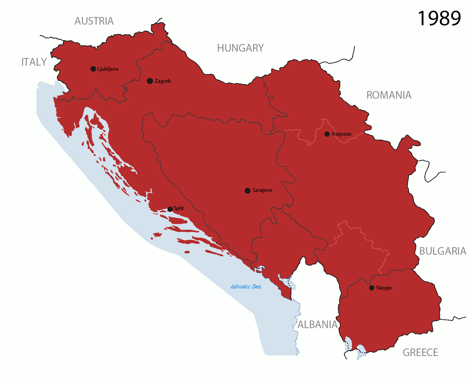
This is an animated GIF that shows the stages of the breakup of the SFR Yugoslavia in the 90's and 2000's. The map based off Morwen's map of the divisions of the SFRY, Which is licensed by the GFDL. The source for the dates of independence is the CIA World Factbook. These maps
Changelog for version 4:
Changelog for version 5:
|
| Datum | 24 July 2006 (orginal upload date) |
| Izvor | Made by Hoshie; see above for more details on sources. |
| Autor | Hoshie |
| Ostale inačice |
|


Licencija

|
Dozvoljava se umnožavanje, dijeljenje i/ili mijenjanje ovog dokumenta pod uvjetima GNU-ove licence za slobodnu dokumentaciju, inačica 1.2 ili kasnija ako ju je objavio Free Software Foundation; bez nepromjenjivih ili obveznih dijelova i bez teksta na naslovnoj i/ili posljednjoj stranici. Kopija licencije je uključena u odjeljak naslovljen GNU-ove licence za slobodnu dokumentaciju. |
| Ova datoteka je licencirana pod Creative Commons Imenovanje-Dijeli pod istim uvjetima 3.0 nelokaliziranom licencijom. | ||
| ||
| Ova oznaka za licenciranje dodana je datoteci kao dio GFDL ažuriranja licnciranja. |
Povijest datoteke
Kliknite na datum/vrijeme kako biste vidjeli datoteku kakva je tada bila.
| Datum/Vrijeme | Minijatura | Dimenzije | Suradnik | Komentar | |
|---|---|---|---|---|---|
| sadašnja | 07:40, 17. srpanj 2016. | | 1.545 × 1.242 (187 KB) | wikimediacommons>מפתח-רשימה | Reverted to version as of 17:22, 21 August 2015 (UTC) |
Poveznice
Na ovu sliku vode poveznice sa sljedećih stranica: