

Vidi sliku u punoj veličini (SVG datoteka, nominalno 1.283 × 981 piksela, veličina datoteke: 511 KB)
| Ova je datoteka sa stranica Zajedničkog poslužitelja Zaklade Wikimedije i smiju je rabiti drugi projekti. Opis s njezine stranice s opisom datoteke prikazan je ispod. |
Sažetak
| Opis |
Deutsch: Dies ist die deutschsprachige Diagrammversion, andere sind unten angegeben.
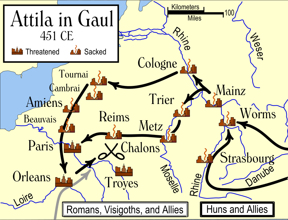
Das Diagramm zeigt die wahrscheinlichen Wege, die von den Hunnen bei ihrer Invasion Galliens 451 benutzt wurden, und die Schicksale der Städte auf ihrem Weg. Die verschiedenen Quellen ergeben widersprüchliche Information darüber, ob Städte geplündert wurden, insbesondere Trier. Es wird auch gesagt, daß einige Städte südöstlich von Troyes einschließlich Auxerre, Besancon und Langres geplündert wurden.English: An historical map showing the Hun invasion of Gaul in 451 CE (AD), leading to the Battle of Chalons. The generally accepted routes are shown, along with the larger cities threatened or sacked by the Huns. Français : Une carte historique montrant l'invasion des Huns de la Gaule en 451 Ap J-C, et la bataille des champs Catalauniques. Les itinéraires probables sont montrés, avec les villes plus grandes menacées ou pillées par les huns. Italiano: Carta storica che descrive l'invasione della Gallia da parte degli Unni nel 451 d.C., e la battaglia dei Campi Catalaunici. Sono mostrati i probabili itinerari, e le città conquistate o risparmiate dagli Unni. Nederlands: Een historische kaart die de invasie van de Hunnen en hun bondgenoten in Germania, Belgica en Gallia in het jaar 451 toont, en de Slag op de Catalaunische Velden. De waarschijnlijke routes zijn getoond maar deze zijn niet met zekerheid te geven, omdat de exacte dag van plundering en belegering in de meeste gevallen niet bekend is. 中文: 匈人入侵高卢,最终发生了沙隆战役。图中展示了普遍认同的双方进军路线,并标记了受到威胁或遭到劫掠的较大城市。 |
||||||||
| Izvor | Vlastito djelo postavljača | ||||||||
| Autor | Vlastito djelo postavljača | ||||||||
| Dopuštenje (Naknadna uporaba ove datoteke) |
Ja, nositelj autorskog prava za ovo djelo, ovime ga objavljujem pod sljedećim licencijama:
Možete odabrati licenciju prema vašem izboru. |
||||||||
| Ostale inačice |
[]
|


References
- Various other sources including the Catholic Encyclopedia articles on the various cities.
Various sources give conflicting information on whether some cities were sacked, in particular Trier. Man says "no", while Ferrill says "yes". Most other sources agree with Ferrill. There are also several cities southeast of Troyes which were said to have been sacked, including Auxerre, Besancon, and Langres.
In order to be as understandable as possible to the average reader, I have used the modern-day names of the towns, rather than the names used in 451 CE.
Povijest datoteke
Kliknite na datum/vrijeme kako biste vidjeli datoteku kakva je tada bila.
| Datum/Vrijeme | Minijatura | Dimenzije | Suradnik | Komentar | |
|---|---|---|---|---|---|
| sadašnja | 03:50, 3. travanj 2009. | | 1.283 × 981 (511 KB) | wikimediacommons>Goldsztajn | removing red-blue colours to black/grey. |
Poveznice
Na ovu sliku vode poveznice sa sljedećih stranica: